Reality Modeling | Context Capture
Reality Modeling Software
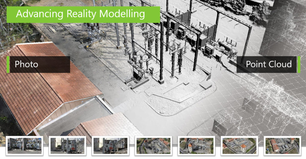
Reality modeling is the process of capturing the physical reality of an infrastructure asset, creating a representation of it, and maintaining it through continuous surveys. Bentley’s reality modeling software, ContextCapture, provides you with real-world digital context in the form of a 3D reality mesh.
A reality mesh is a 3D model of real-world conditions that contains large amounts of triangles and image data. Each digital component can be automatically recognized and/or geospatially referenced, providing you with an intuitive and immersive way to navigate, find, view, and query your asset information. You can use reality meshes in many engineering, maintenance, or GIS workflows to provide precise real-world digital context for design, construction, and operations decisions.
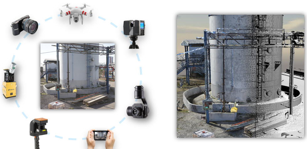
Overlapping photos from drones and ground-level imagery, supplemented by laser scans where needed, ContextCapture enables you to generate spatially-classified and engineering-ready reality meshes at any desired level of accuracy and scale, including an entire city.
TECHNICAL OVERVIEW:
Consume imagery from many cameras and sensor types
- Utilize a wide variety of cameras, from smartphones to highly-specialized airborne or terrestrial multidirectional acquisition systems. Take advantage of any available image format and metadata to create 3D models.
Consume laserscan data
- Import static or mobile laserscan data. Combine it with photos to get very high accuracy reality meshes.
Create animations, videos, and fly-throughs
- Produce high-resolution orthographic and perspective images by rendering snapshots of any size. Set image size and scales using output rulers, scale, and positioning for accurate reuse. Take advantage of the intuitive time-based fly-through and object animation system for quick and easy movie production.
Create high-fidelity images
- Use high-fidelity imaging tools to support precision mapping and engineering. Combine imagery in virtually any format and projection.
Create scalable terrain models
- Use and display very large terrain models to increase return on investment on large datasets. Display scalable terrain models in a variety of modes, such as smooth shading with shadows, aspect angle, elevation, slope, contours, and more. Synchronize terrain models with source data such as DGN files, point-cloud data, and more.
Employ parallel computing power
- Dramatically reduce processing time with the ability to run two ContextCapture instances in parallel on a single project.
Generate 2D and 3D GIS models
- Produce accurate georeferenced 3D models using a full range of geospatial data types including true orthophotos, point clouds, raster digital elevation models and Esri I3S format. Includes an SRS database interface to ensure interoperability with your GIS solution of choice.
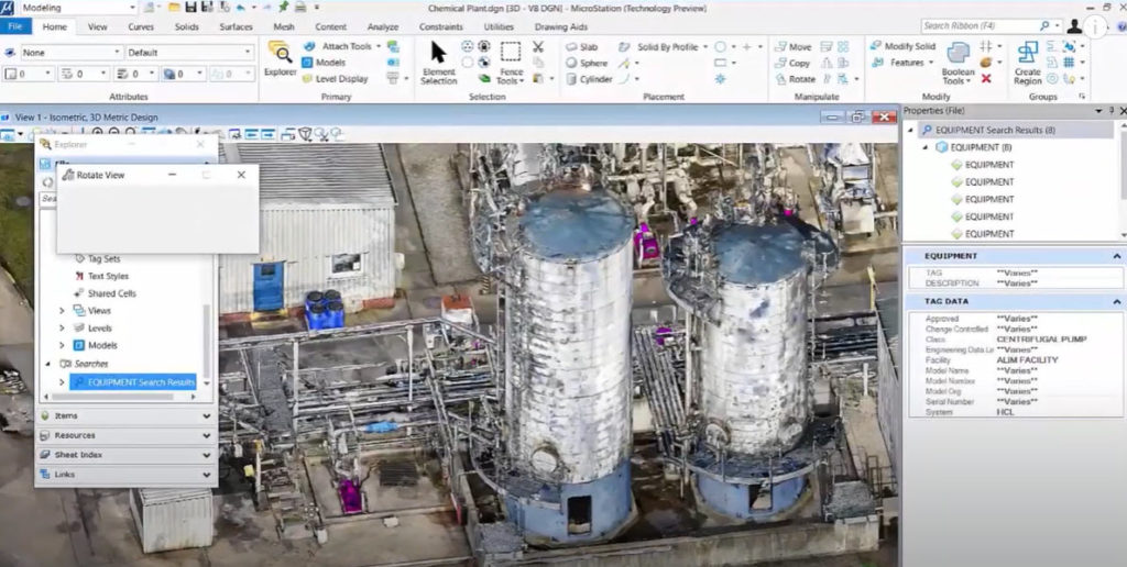
Integrate data from many sources with reality meshes
- Enrich reality meshes with additional data like geospatial information, by attaching it to specific parts of the mesh, providing the ability to subsequently search and visualize regions of a mesh based on the associated data.
Integrate positioning data
- Leverage ground control points or GPS tags to precisely georeference models. This enables you to geocoordinate your project and accurately measure coordinates, distances, areas, and volumes.
Measure and analyze model data
- Save time getting accurate answers by performing precise measurements of distances, volumes, and surface areas directly within the 3D viewing interface.
Model geometry from reality modeling data
- Extract break lines, paint lines, surfaces, planes, cylinder, and cylinder center lines from reality models. Efficiently clip and section point cloud and reality meshes to streamline vector extraction.
Perform automatic aerotriangulation and 3D reconstruction
Perform automatic photo block alignment on point clouds
Perform simultaneous navigation and viewing in 2D images and a 3D reality mesh
Publish and view Web-ready models
Scalable production speeds with cloud on-demand
Visualize, analyze, and measure reality meshes prior to final production
Visualize, manipulate and edit reality modeling data